The Dolmens in Ganghwa Island

Standard

Dolmens are megalithic structures that mark graves of ancient people, mostly from the Bronze age. While dolmens exist in many corners of the globe, The Korean peninsula is home to almost 40% of all the known dolmens! As a nod to this exceptional patrimony, three outstanding dolmen sites were given UNESCO World Heritage Site (WHS) statuses in 2000. In April 2019, I managed to check out the dolmen group in Ganghwa island, which is thought to house the earliest ones of the northern table-type form in Korea.

dsc_0219.jpg

The Ganghwa dolmens are scattered across the island, and are grouped into clusters. Originally, I wanted to combine Bugeun-ri cluster, the main one, with another; Osang-ri, the closest, was a good candidate but it still lies a few kilometers away. This was because I thought that seeing just the big dolmen, officially named Bugeulli jiseok dolmen, provides a rather thin  visitor experience for such a long day trip outside of Seoul. While many online sites detail how travelers can get there, I differ by sharing how I got the best out of Bugeun-ri seeing how many visitors do not venture out beyond the big dolmen.

DSC_0259

Studying the core zones of the dolmen clusters in Ganghwa island, the map indicates that there are 16 more dolmens that are part of Bugeun-ri. True enough, during the time of my visit, it seemed that the dolmen park is undergoing some further expansions at the back to include four more extant dolmens not so far away — one, which is half buried, seems to be even bigger than the capstone of Bugeulli jiseok.

DSC_0254

DSC_0274

As the weather was very inviting —sunny but cool and breezy— I also decided to walk further into the adjacent hill forest after gathering leads that it contains the other lesser-known dolmens. My wanderings there did not only allow me to see all the World Heritage-inscribed dolmens in Bugeun-ri. Rather, it also afforded me very close encounters with two wild Korean water deer, cute black fur squirrels, and some birds! The pleasant walk took a little bit more than two hours, back and forth, and I did not encounter any other person at all. There is a certain joy and excitement in exploring remote places alone, and I achieved that here.

DSC_0277

DSC_0342

One interesting dolmen there clearly shows carved holes, suggesting the method and outline that the Bronze age builders used in cutting these megaliths. Although most of the extant dolmens are the unsupported capstone type, there are a few table type ones that have collapsed. All are properly marked with their respective dolmen number and the WHS logo, and are fenced. Surprisingly, in the middle of the forest, there was even a very neat information board about this World Heritage Site — I wonder how many people really take the effort and time to get into that area, though. There is also one dolmen that seems not to be a part of the inscribed ones, but it is also protected on a local level as evidenced by a different marker used.

DSC_0309

DSC_0319

While I enjoyed an exclusive 15 mins with the big dolmen very much (that’s a pretty long time, if you think about it, to appreciate a set of three big stones), I found the excursion I did in the outskirts to be more memorable and fulfilling. I have yet to see Gochang and Hwasun, the other two dolmen groups down south which are more praised, but, for now, I can say that I’ve been well contented with what I saw in Ganghwa.

Indonesian Batik

Standard


Batik is a pan-Southeast Asian artform often associated with Muslim communities. It is a technique that involves wax-resist dyeing on a cloth, where the artist applies wax, following a desired pattern, through an instrument called canting. This is done prior to soaking the cloth to a dye solution in order to achieve color/s. The wax is then melted later on with hot water, revealing the difference between the dyed and the undyed portions. The appeal of this traditional art has become so influential and far-reaching that it has successfully found a place in mainstream fashion.

DSC_1269

A batik master artist from Mirota Batik shop in historic Jogjakarta

dsc_1294.jpg

A male batik artist spotted in the village inside the Jogjakarta Kraton (palace complex)

Indonesian Batik is considered to be the best, and it has been inscribed as a Masterpiece of Oral and Intangible Heritage of Humanity by UNESCO in 2009. It utilizes various motifs and inspirations not only from Islamic designs but also from Hindu-Buddhist, European, Chinese and even local ones, illustrating the cultural syncretism manifesting in the country.

DSC_1275

Various Indonesian Batik on display in one of the cloth shops along Malioboro street in Jogjakarta center.

As with other heritage textiles, the batik also plays an important role throughout the entire life cycle of an Indonesian, from life to death, making it a truly national icon. Every October 2nd, Indonesia celebrates “Batik Day”, commemorating the momentous day that the Indonesian Batik was added to the prestigious list.

Arguing for Historic Elim, South Africa

Standard

One of the most pleasant surprises that we experienced in South Africa was when we decided to make a stop at a historic town, declared as a national monument, on the way to the Boland region from The Republic of Swellendam.

DSC_0560

Elim, a Moravian mission station established by German missionaries in 1824, retains much of its original textures, scoring high both in authenticity and integrity. Backdropped by the Capefold mountains, this quaint town is one of the few remaining ones in South Africa still owned and managed by the church. Here are five things to definitely love about Elim:

ONE. Technological Advancement: The white churh’s 1757-built clock is regarded as one of the oldest working public clocks in the country. It is also ran by a long mechanism driving the two clockfaces mounted on both gables of the building, making it the only clock with an axle length of 26m there is to find.

DSC_0537


TWO. Town Planning and Vernacular Architecture: Its central axis leading directly to the church, which is flanked by two rows of nearly identical single-storey houses, is a delightfully neat sight. These houses differ a lot from the more ubiquitous Cape Dutch gabled houses. The carefully carried out town planning is not hard to notice.

DSC_0568


THREE. Memorial to a Historical Event: In front of the town’s library, which is housed at the former school building, is the only monument dedicated to freed African slaves in South Africa. It was ereceted in 1938, four years after the abolition of slavery in the Cape.

DSC_0544


FOUR. Engineering Feat and Water Control: Elim is home to the oldest functioning watermill in South Africa, which is also declared as a national monument on its own right in 1974.

DSC_0584


FIVE. Intangible Cultural Heritage: Renowned for its uniform thatched roofs, which are reminiscent to those found in Friesland in Germany, its residents are considered to be some of the best thatchers in the world. Utilitizing only restios locally found in the region, this aspect of Elim is clearly its most distinct living tradition that has been passed down from one generation to the next.

DSC_0559

All these elements, together with the fact that there were no other tourists roaming around when we were there, made our three-hour stay in Elim very memorable and fulfilling. Also, while there is no German-built colonial space listed yet as a UNESCO World Heritage Site, the potential of Elim to be one is quite promising and is something that South Africa should consider.

Tiong Bahru, a Thought on Heritage

Standard

Singapore’s first public housing project surprisingly retains the textures of the then emerging international style and Art Deco movements in architecture. Tiong Bahru is a true heritage spot and an exceptional example of a planned urban space that is still glossed over by most who visit this bustling city in a garden.

DSC_0442

There are two reasons that I can think of for this:  the area hardly makes it to guidebooks, which sadly reflects the truth that what gets written in the pages are simply those that the writers just want others to see and know and there have been cases that they do NOT really know enough; and, more importantly, modern architectural movements still rarely appeal to many in ways colonial Straits shophouses do, as in the cases of Chinatown, Kampong Glam or Little India. It seems that the lack of “romance” and “ancientness” around the former hinder the interest of the average person towards them.

DSC_0444

DSC_0440

In an advanced city now known for its modern marvels, how much attention and appreciation can really be accorded to the last remaining built-heritage around? It seems that turn of the 20th-century architecture suffers the most undervaluation and apathy, and Tiong Bahru’s case illustrates this phenomenon clearly.

DSC_0429

DSC_0439

But how did I get there, to begin with? A friend took me there primarily for the food offering in Tiong Bahru market — which is amazing! The buildings were really a big surprise to me as I did not know anything about them beforehand.

DSC_0433


The Persian Garden

Standard

In our trip in May 2017, we ticked off three: Fin garden in Kashan, the ancient garden in Pasargadae, and Eram garden in Shiraz. We also had a fair glimpse of Chehel Sotun garden in Esfahan from its gates. Generally, it is imperative to visit at least one Persian garden in any visit to Iran and it is not hard to find one, although only nine are inscribed as UNESCO World Heritage Sites (WHS). However, after having seen India’s Persian gardens earlier in 2015, which were adopted by the Moghuls using no less than Persian artisans, how should we appreciate the Persian gardens from the country where the tradition originated?


DSC_0319

Kashan’s Fin garden


We visited Bag-e Fin on a Friday, which was not the best day to be a tourist in Iran since it is their weekend. Expecting tranquility and peace in the oldest functioning Persian garden in the world that was built in 1590, what welcomed us was a garden fully packed with locals picnicking and groups occupying every known space inside. Sadly, knowing that we enjoy taking photos, the experience did not turn out the way we expected it to be. If there was any consolation, however,  at least the waters were flowing, all the fountains were working, the pools were not empty, and the water source, the Solomon’s spring (a qanat opening that also feeds water to the T-Listed Tepe Sialk), can be publicly seen at the back. There were other attractions inside (ridiculously with separate entry fees!), but we no longer bothered giving them a try due to the long queues. Another thing that impressed me was that the garden is surrounded by thick and high mud walls typical in the desert region.


DSC_0121.JPG

Pasargadae’s ancient Persian garden


The 6th century BC-built ancient garden of Pasargadae is in ruins. Only the remains of the stone layout, watercourses, and fountain pools are left. One can only then re-imagine how the garden might have looked like during its heyday out of these relics — a leisurely activity that my good friend found difficult to enjoy. The garden was the realization of Cyrus the Great’s desire to recreate paradise on earth. The river that cuts through the capital used to supply the water needed for the garden via canals. We, however, did not see any tourists who paid any attention or interest in the ruins of the garden. This is despite the fact that the garden is an interesting case: while the garden is a WHS in its own right, it also happens to be located inside another WHS, Pasargadae (as a testimony to the first capital of the Persian empire). The inscription of the Pasargadae garden, ultimately, is a nod to the provenance of the Persian gardening tradition. The presence of a signage explaining this, as well as visual re-creations of the garden, might prove beneficial to visitors.


DSC_0565

Shiraz’s Eram garden


Bag-e Eram, which is now managed by a local university, is bigger than the one in Kashan, allowing more spaces for roaming around. The Qavam pavilion, which serves as the backdrop of the garden, is a pleasant work of art and architecture from the Qajar period. What we enjoyed the most there was the abundance of many local plants and trees, some were even in bloom during our visit. The only sad thing about Eram was that the water courses and fountains were dry, something that has been reported to be the case for quite some time now. A friend we traveled with from Yazd to Shiraz just had to compare it with the Bag-e Shahzadeh in Mahan, which has an abundant water supply despite being in the Lut desert region. Nevertheless, Bag-e Eram was the redemption we needed to truly experience a Persian garden eventually.


DSC_0155

India: Taj Mahal’s Persian Garden


Assessment: while there are more to appreciate in the Persian gardens in India (the Taj Mahal and Humayun’s Tomb, for example), the pleasure derived in visiting the Persian gardens in Iran lies in the fact that they represent the pure form of this gardening tradition that reflects Persian philosophy and ingenuity, mainly in their mastery in the use of water for the gardens’ survival and aesthetics. Overall, the Persian gardens are humble, modest and unpretentious gardens. I, however, cannot imagine having the need to visit more than what we have seen — 3 was more than enough to get a proper feel of what this UNESCO WHS has to offer.

The Persian Qanat (Zarch Qanat)

Standard
This is probably the UNESCO World Heritage Site I spent the most time in trying to understand how to “properly” visit it during my recent trip in Iran. When I was just about to give up on it, a sign suddenly emerged in the streets of the historic city of Yazd referring to the “Zarch Qanat gallery”. This seems to be an improvement since the last reviewer from our WHS community went to Yazd in 2016, reporting the glaring lack of any public information about the qanats.
DSC_1322

A signage that gave me hope. This is one of those that have been mounted on the mud walls of the old city of Yazd to show where the qanat flows underground.

Later on, my friend and I realized that there were in fact a lot of signs all over showing some sort of a direction. Only to find out that — after intently and passionately following the signs for nearly an hour — it was not really leading us to a “gallery” (i.e., an exhibit, a museum, or a showroom)! Rather, it was just illustrating where the qanat flows underneath the city! This finding was interesting, but it was far from constituting a “proper” visit.
DSC_1390

The stairway of the Jame Masjid payab, an access to the Zarch qanat inside the Great Friday Mosque of Yazd

Much to my surprise later that day, however, we eventually got the proper visit that we needed no less than inside the Great Friday Mosque itself. It was a sweet accident that I will always be grateful for. At the main gate of the mosque, I already wondered why there was a banner congratulating “… the successful inscription of the Persian Qanats as a UNESCO World Heritage Site”. Sadly, it obviously and shamefully failed to indicate the more important detail, i.e., that a part of the qanat can actually be accessed within it. Inside, there is a small opening on the ground that can easily be missed which leads to a payab (underground water chamber). This payab, which has been supplying the mosque the water it needs since it was erected 700 years ago, is one of the public openings of Zarch. The properly lit stairway goes down to some 30 meters below the ground until one reaches the well.
DSC_1383

The well inside the water chamber 30 metres under the Great Friday Mosque of Yazd

Surprisingly, during our two hour wandering inside the complex, despite the hoards of tourists visiting the mosque and the no lack of tourist guides around, we only saw two other curious visitors who took the effort to go down the site, and they probably were not even aware of what it is at all. Even in the free walking city tour we hopped on the following day, our guide never mentioned anything about the qanats and their importance. We also learned later on that the Zarch qanat runs as well under the Emir Chaqmaq complex, but going there proved futile – there is no way to “see” the qanat.
DSC_1325

Courtyard of the Great Friday Mosque of Yazd and the small, unpretentious entry to the payab in the foreground. The tourists do not even find their way to go to the other end of the courtyard to realize that a qanat can be seen there.

In one of those cosy coffee shops in the city, I had a talk with its owner whom I shared my sense of achievement and pride in seeing a part of the Zarch qanat with when I least expected it. What he did next was something unexpected. He enthusiastically showed us a ground cover in front of his shop, opened it, and explained that it’s one of the shafts of Zarch. It was quite deep and one can hear the flowing water well!
DSC_1706

One of the vertical shafts of the Zarch qanat in front of a coffee shop in the old district of Yazd.

He also told us about the old underground watermill of Koushk-e No in the neighbhorhood which is also being repaired (or prepared) at the moment to become a tourist showroom for the qanat. Furthermore, he advised that if we go there, and if we’re lucky, we might just have a peek inside. And we eventually did.
DSC_1729

The actual watermill is on the second level of this qanat access. The fenced off area is the access to the lowest qanat in this intersection.

Going down through its small opening, several layers of water channels and chambers were seen. Apparently, the site lies at the crossroad of three different qanats, with the Zarch qanat specifically powering the mill. It is also interesting to know that the temperature on the ground compared to the temperature down where the waters flow can differ from 17 to 20 degrees Celsius, making it a wonderful refuge from the heat outside.
DSC_1758

A fresh water flowing on the Zarch qanat! Nothing has changed much in the three millenia of its existence – it is still working.

The Zarch qanat has been supplying most of the water requirements of the desert city of Yazd for more than 3,000 years already. It also happens to be the longest qanat in Iran at 120 kilometers in total length. In its entire course, from the mother well (water source) to the farmlands it irrigates, more than 2,000 shafts have been constructed. Indeed, qanats are a proof that ancient Persians were masters in hydraulic engineering.
DSC_1931 (41)

The forest of badgirs, or windcatchers, in the historic desert city of Yazd at dusk.

The Zarch qanat definitely plays an important role in the nomination of the Historic City of Yazd, which also has a living tradition registered in the Masterpieces of Oral and Intangible Heritage of Humanity, as a UNESCO World Heritage Site on its own right. This proposal will be decided upon this coming June when the committee convenes in Krakow, Poland. I sincerely wish Yazd the best of luck.
********
Albeit not among the World Heritage-listed properties, other qanats we saw in the trip include the Solomon’s spring, an opening of a qanat that feeds water to the Fin Garden, a UNESCO World Heritage Persian Garden, and the 7,000 years old Sialk Tepe, the remains of the oldest known ziggurat, in Kashan; and the qanat that supplies water to an ancient caravanserai, refrigerator, and ice house in historic Maybod, another desert city along the Silk Road that is also in Iran’s present Tentative List for UNESCO WHS listing.

Cape Floral Region Protected Areas

Standard

Inscribed in 2004, followed by an extension in 2015, with the following justifications:

Criterion (ix): The property is considered of Outstanding Universal Value for representing ongoing ecological and biological processes associated with the evolution of the unique Fynbos biome; and,
Criterion (x): The Cape Floral Region is one of the richest areas for plants when compared to any similar sized area in the world. It represents less than 0.5% of the area of Africa but is home to nearly 20% of the continent’s flora.  The outstanding diversity, density and endemism of the flora are among the highest worldwide. (source: http://whc.unesco.org/pg.cfm?cid=31&id_site=1007)

DSC_0293.JPG

A large part of my personal satisfaction in being able to tick this site off last 2016 stems from the fact that not only were my friend and I able to see the three nature reserves that form the Table Mountain National Park (i.e., Table Mountain, Silvermine and Cape of Good Hope), but, more importantly, we was able to pay proper visits to seven out of the eight protected areas that make up the inscribed serial property. We only missed out Groot Winterhoek Wilderness Area.


DSC_1025.JPG

Table Mountain National Park embracing Cape Town as seen from Bloubergstrand beach


DSC_1214.JPG

Different kinds of fynbos in Kirstenbosch Botanic Garden with the “Tableback” part of the Table Mountain in the background.


The Cape floral kingdom is a truly unique ecosystem dominated by the fynbos,  a plant vegetation (i.e., proteas, ericas, restios and some lilies) that practically only exists in this corner of the world.  Kirstenbosch Botanic Garden, which is the only botanical garden in the world located inside a UNESCO natural world heritage site, provides a bird’s eye view of the different species of fynbos that thrive across different habitats, and it would be best to start one’s travel here. We, however, started with the Baviaanskloof moved towards Table Mountain, then went up to the Cederberg, and finally made the botanical garden our last stop upon returning to Cape Town.


DSC_1154.JPG

Cape Floral Region: the smallest floral kingdom in the world, the densest, and the most threatened as well, a patrimony of the world of the highest order.


Here are some of the highlights:

(a) the beautiful mountain scenery provided by the Swartberg Pass and the Merringspoort Pass. Both connect the Little Karoo and the Great Karoo, and are great feats of mountain engineering;


DSC_1345.JPG

Ericas (a kind of heaths) growing among the rocks on top of the freezing cold Swartberg peaks.


dsc_1358

The world-famous Swartberg Pass and the montane fynbos that cover the landscape


(b) the rock formations of the Cederberg and its extensive collection of ancient Bushmen paintings (we stayed overnight in the wilderness to see the Sevilla rock art trail);


dsc_1390

The rock formations of the Cederberg mountains, the only place where the fynbos called rooibos thrive. It is cultivated to make a tea drink of the same name (or red tea in the West).

DSC_1429 (39).JPG

One of the 3,000 year-old rock paintings made by ancient San people in the Cederberg near Clanwilliam.


(c) the coastal white sand dunes and game drives in De Hoop Nature Reserve and Protected Marine Area;


DSC_0379.JPG

Constantly reshaped white sand dunes of De Hoop show how strong the coastal trade winds are in this whale-watching area.


DSC_0407.JPG

Spotted a herd of Bonteboks, the rarest of African antelopes, in the grasslands. Other animals spotted were ostriches, Cape buffalos, wildebeasts, kudus, and various birds.


(d) views of Strand, Stellenbosch, Franchshoek, Botrivier and the rest fo the Boland area/wine region on top of the Hottentots-Holland mountains;


DSC_0650.JPG

At the highest point of Sir Lowry’s Pass in the Hottentots mountains, which caught wildfire a few days after we passed through it in getting to Cape Town.


dsc_1695

Inside one of the heritage wine estates in Stellenbosch with the Boland mountains in the background


(d) scenic coastal drives along the Cape of Good Hope and Kogelberg biosphere reserve — very enjoyable!;


DSC_1634.JPG

A tourist imperative: a photo shot with the Cape of Good Hope marker inside the Cape of Good Hope Nature Reserve


DSC_1837.JPG

The mountain-to-sea view as one traverses the Kogelberg Biosphere Reserve along the coastal road.


and (e) the imposing beauty of Table Mountain as seen in and around Cape Town – indeed a true world-class landmark! Also memorable was the walk along the penguin colony in Simon’s Town, which is part of the inscribed property as well.


dsc_0962

The top of Table Mountain beginning to be covered by the “table cloth” clouds

dsc_0960

Cape Town and Cape Bay as seen from the Table Mountain


Overall, the outstanding universal values of this serial property is not hard to understand and appreciate. Each protected area is different from one another, and all of it are definitely worth visiting.


dsc_1200

Another species of the endemic protea, South Africa’s national flower


PS. Special thanks to Wolffie for making the trip possible and wonderful!

Filipino Culture & History through the Northern Philippines

Standard

The Philippines has a rich history and culture, but we sometimes do not understand the country well enough to realize to what extent. It is not a question of whether we have it or not. Rather, it is of how much we really know and are aware. One way to get reacquainted with the Filipino identity and our past is by taking what I would call as a heritage trail up north. The beauty of Northern Philippines lies on the fact that it is home to four UNESCO World Cultural Heritage Sites.

What does this mean?

dsc_1242

A UNESCO World Heritage Site (WHS) is any given natural or cultural place, monument or landscape that holds outstanding universal values critical to the development of humanity, and which reflect diversity. Some of the more popular WHS around the world include the Great Wall of China, the Stonehenge, the Taj Mahal, Chitchen Itza, the Table Mountain, the Great Barrier Reefs, and even the Statue of Liberty. Regardless of popularity and fame, however, all of these places are treated with equal degree of cultural and historical importance.

With the recent addition of Mt. Hamiguitan Range Wildlife Sanctuary in Mindanao in 2014, the Philippines now has six sites listed as WHS. Two of which are marine natural sites in Palawan, the Puerto Princesa Subterranean River National Park and Tubattaha Reefs Marine Park. Both of these sites are also declared as Ramsar wetlands of international importance. The other three are cultural sites found in Northern Philippines: the Rice Terraces of the Philippine Cordilleras, the Historic Town of Vigan, and the Baroque Churches of the Philippines.

From Manila — where San Agustin church, another WHS, is found inside Intramuros — one can make a Do-It-Yourself trip in taking on this heritage trail. A bus from Manila can take you to Banaue, the jump-off point for the rice terraces. From there, vans can be arranged to bring you down to Vigan. Sta. Maria is also along the way to Vigan, and finally, going further north by bus will bring you to Paoay in Ilocos Norte. Each place offers a taste of the depth of Philippine history and Filipino ingenuity.

Rice Terraces of the Philippine Cordilleras

Agricultural terracing is not unique to the Philippines. China, Indonesia, and Viet Nam have it. Peru and even Switzerland have this method, too. What makes the rice terraces in the Philippines unique is that they are the oldest and most extensive continually-used rice terraces in the world. As a comparison, these rice terraces have been around much longer than Machu Picchu or Angkor have! The more noticeable distinguishing marks of these engineering marvels would be their heights that reach as high as 1,500 metres from the base, and their steepness that defies limits with 70 degrees maximum angulation.

dsc_0231-2

The incredible mixture of purely man-made terraces, the mountains, the muyongs (forest caps), traditional hamlets, and other visible cultural artifacts in the region certainly does not disappoint. The Food and Agriculture Organization has cited the rice terraces as an outstanding example of “worldwide, specific agricultural systems and landscapes (that) have been created, shaped and maintained by generations of farmers and herders based on diverse natural resources, using locally adapted management practices.” The American Society of Civil Engineers also named the rice terraces as a ‘Historic Engineering Landmark’ for water supply and control. In 1997, the same group came to the Philippines and formally declared (through a marker) the rice terraces as the [original] 8th Wonder of the World.

dsc_0144-2

For the Filipinos, with the mode of farming and the people’s lifestyles largely unchanged, these ancient rice terraces are an enduring portrait of the ways of life of the Ifugao for over 2,000 years. The WHS-listed clusters are Batad, Bangaan, Hungduan, Mayoyao and Nagacadan rice terraces. Hungduan is also one rare site in the world as it is home to no just one but two UNESCO Masterpieces of Oral and Intangible Heritage of Humanity, the Hudhud chants and the Punnuk.

Historic Town of Vigan

Why does this small town merit a special place in the collective memory of the Filipino people? It is one of the few towns in the country that was spared from destruction during the World War II (Intramuros, Manila’s walled district, was razed to the ground and only one building was left standing there after the war). Being the best preserved Spanish colonial-era trading town in Asia, Vigan presents itself as an intact and authentic old town. It boasts a good collection of original houses wherein the ground floors are characterized as Hispanic, while its upper floors and windows suggest Chinese and Oriental influences. The best of these houses can be seen along Calle Crisologo, a re-created cobblestone street.

historic-town-of-vigan

One will notice that the town faithfully follows the historical “quadricula” or “grid” street plan. This, believe it or not, is the most ‘Hispanic’ feature of the town. The interior of a typical Vigan villa can be seen when visiting the likes of the Sy-Quia mansion, the family house of the former President Quirino.

historic-town-of-vigan-2-1

In 2012, Vigan bagged the ‘Best Management Practices for a World Heritage City’ award in a worldwide competition by UNESCO. And again, three years later, Vigan was voted as one of the Seven New Wonder Cities in the World through a global online poll.

Baroque Churches of the Philippines: Sta. Maria

Aside from the San Agustin church inside Intramuros and the Miag-ao church in Iloilo, the Northern Philippines boasts two of the best examples of Philippine Spanish-era churches. The town of Sta. Maria, some 40 minutes south of Vigan, houses a citadel church built on top of a fortified man-made hill. In the older days, the only way to reach the church is through the 82-step staircase made of granite slabs, making the complex easily defended.

dsc_0813

Made of red bricks, the Asuncion de la Sta. Maria church boasts a set of massive buttresses that supports the structure from the damages of earthquakes. The pagoda-shaped bell tower is leaning due to the collapsing retaining walls around the hill, which placed this church in the ’100 Most Endangered Sites’ in 2010 by the World Monument Watch of the World Monument Fund.

Baroque Churches of the Philippines: Paoay

The crowning gem of the “earthquake baroque architecture” is the San Agustin church in Paoay. This edifice is largely made of coral stones that have been glued together using egg whites, lime powder and molasses. This important church features a mixture of Oriental, Malay, and Western influences in its design. This comes as no surprise as long before the Spaniards reached present-day Paoay, the site was already a trading settlement known as Bombay in earlier records.

dsc_0924

Keen eyes will notice some fading carvings and bas-reliefs around the church. The most important exponents of this church are definitely its beautifully-constructed massive buttresses. Paoay church is considered to be a masterpiece of the Filipino reinterpretation of the baroque movement, fusing European principles with local Filipino craftsmanship. The bell tower is also separated from the church as a precautionary measure against the effects of earthquakes – this architectural innovation is unique to Philippine churches.

The churches of the Philippines are unique, and, thus, cannot be compared to those found in Europe or Latin America. As religious monuments, they are key in spreading further the Christian faith in the region (Southeast and East Asia, and the Pacific Islands). While as cultural specimens, they embody the artistic, technological, and intellectual interchange between the West and the East for more than three centuries.

While knowing and understanding Philippine history and culture is a large part of what I do as a heritage advocate, the biggest challenge is in making others see and appreciate things the way I do.

dsc_2264

I often have a hard time convincing friends who have already settled abroad to come back home to re-experience their native land. Most of them would rather spend their vacations going around Europe or elsewhere in Asia to see cultural and grand ancient monuments or old towns, believing none exist here.


The Defenses of Currimao

Standard

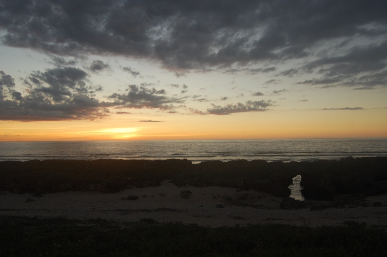
Ever since I was a kid, Currimao in Ilocos Norte has always had a special place in my heart. It has decent packets of beaches very close to where I live, making it an easy weekend getaway. Pangil, one of its barangays, offers what I would describe as the site of the most romantic sunset one can witness in the north thanks to its dramatic rocky landscape. It’s very easy to fall in love with it. Aside from this, however, I did not know anything else about this small, sleepy town by the sea.

Well, until recently[1].

A Reminder of the Tobacco Trade

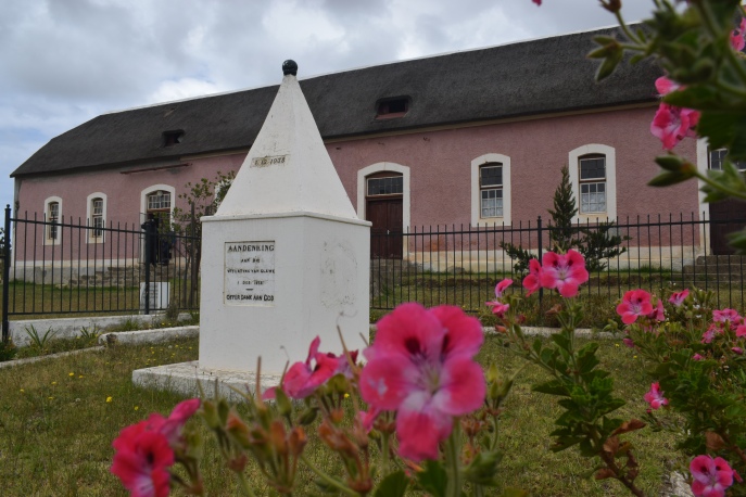
During the Spanish period, Currimao, which was still a  part of Paoay, was a commercial port that played an important role in the tobacco trade. The northern Philippines was then known to have focused on this cash crop, supplying not only local demands but even those from overseas. The town has an 1869-built almacen, popularly known today as the tabacalera, which was used by the Compania General de los Tabacos de Filipinas. There are two other extant tabacaleras in the province, one in Laoag[2] and another in Dingras. But, what makes Currimao’s tabacalera special is that it was at the forefront of the trade given its strategic location and access to the open waters.

IMG_20160314_173944

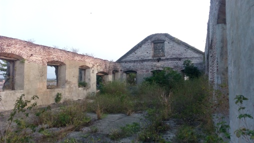
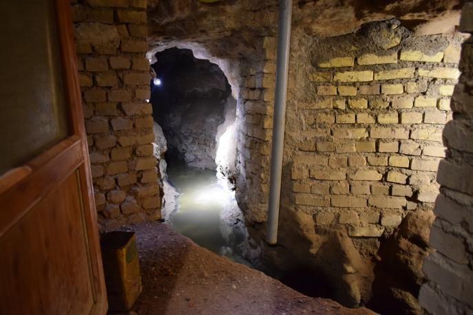
Inside the tabacalera ruins

The massive structure follows a simple rectangular floor plan, with all sides supported by identical buttresses reminiscent of earthquake baroque churches. It also has gabled ends and what appears to be a portico on the main portal. Vestiges of an old perimeter wall made of the same materials used in constructing the almacen – rocks, coral stones and ladrillos – can be found around it as well.

IMG_20160314_193544_720

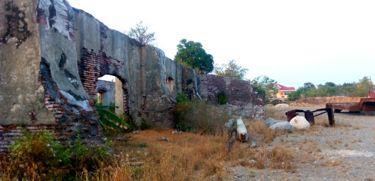
Exterior of the tabacalera with its buttresses, and the mess around it.

Given its already fragile condition, what is more disturbing, however, is the obvious neglect of the site by the locals. Currently, it is used as a heavy equipment and motor pool, as well as a dump site for gravel and aggregates for construction works. This is alarming because its state of disrepair might jeopardize the ongoing process to designate the site yet another National Cultural Treasure – a procedure to be completed, hopefully, by next year[3].

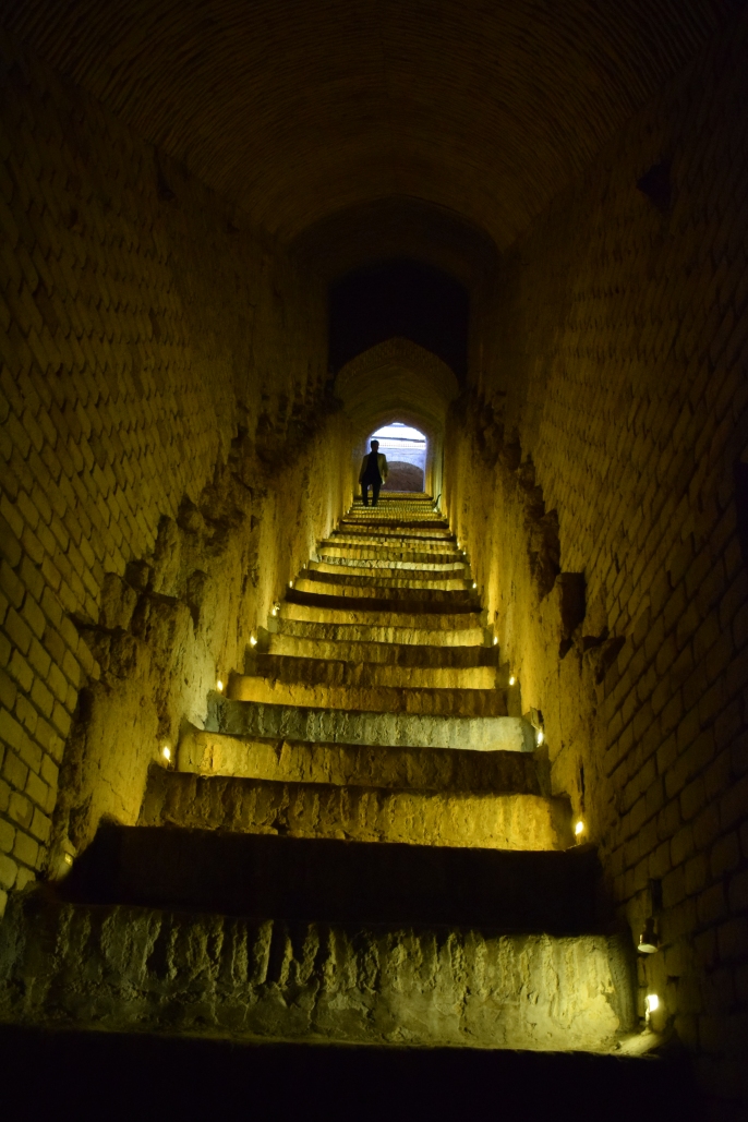
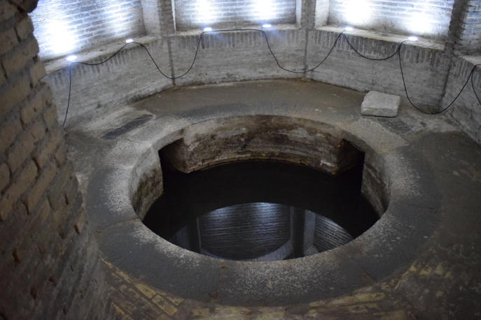
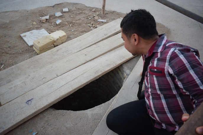
The almacen sits just a few meters away from an old yet still functioning pantalan or wharf that is made of coral stones[4]. This, however, was cemented with concrete a few years ago giving a very modern appearance to it nowadays. Also, close to the almacen, to its left, is another ruins of what might have been the aduana or the customs office[5]. Presently, the remains of this brick edifice is within a private property and no one really knows  what will happen to it nor can anyone guarantee its preservation. Furthermore, a few meters again from the ruins is an agua del pozo[6] or a water well. Aside from it still being used, what is more impressive about this simple structure is that it is dated: 12 de Diciembre de 1878 ano.

IMG_20160314_190645_984

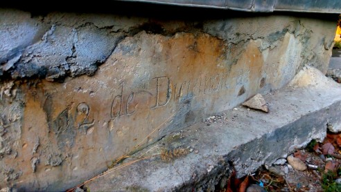
The Spanish period well with the date of its construction

Man-made Fortifications

Across the archipelago, there are hundreds of watchtowers and fortresses built by the Spaniards in their attempt to fortify their empire in the Pacific[7]. Ilocos Norte alone has six, and neighboring Ilocos Sur has five. The existence of a twin watchtowers or garitas only reinforces the historical – and commercial – importance of Currimao as a port. In the Philippines, I am only aware of one other town where a twin watchtowers also exist: Romblon, Romblon[8]. Furthermore, the twin watchtowers of Romblon and Currimao have another striking resemblance: their fortifications can be found at either ends of their poblacion harbour. Their only difference is that, for Romblon, the watchtowers were meant to guard over the pueblo with a church, while Currimao’s were meant to watch over a coastal settlement with a tabacalera.

IMG_20160314_171610

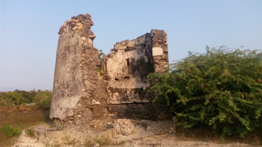
The eastern watchtower

The more obvious of the two watchtowers in Currimao is partly damaged as a segment of its wall has already collapsed. This one is noticeable at any point along the seawall as it prominently stands at the eastern end of the harbour, without any obstruction surrounding it[9]. The other watchtower, which is still complete, is currently heavily vegetated. Several concrete structures have also already been built around it, thus compromising its visual integrity[10]. Both of these watchtowers, which stand approximately seven meters high, are thought to have been built in the mid 1800s or even much earlier.

IMG_20160314_164926

The western watchtower

Despite having been declared as National Cultural Treasures in 2015 under the serial inscription “Watchtowers of Ilocos Norte”[11], there is still the urgent need to conserve and restore the structures that are clearly under threats caused by human negligence and natural disasters.

The Coral Rocks as Natural Barriers

Currimao also boasts a unique landscape and seascape. It is home to a very long coral rock formation along its coast. The entire length of this geological curiosity spans nearly three kilometers, and the best exponents of it are found in Barangay Pangil.

IMG_0407

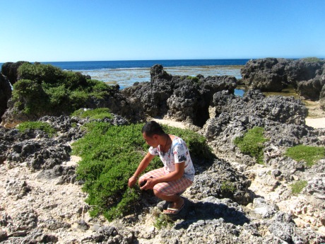
The sharp coral cocks make it impossible for boats and ships to get any closer than 100 metres to shore.

What many might not realize, however, is that these sharp ancient rocks form a durable wall, which creates a natural fortification for the community. During the time when the tobacco trade was at its peak (as a component of the Galleon trade), threats from invading Moros and Chinese pirates were very common in the area. This is also the reason why the watchtowers have come to be known locally as the Moro watchtowers. But, given its rocky shores, boats, let alone ships, cannot dock just anywhere; the rocks and waves make that impossible. Hence, anyone who wished to make a landing would have to go to the only area devoid of coral rocks – the poblacion harbour.

The coral rocks in Pangil can reach as high as four meters tall.

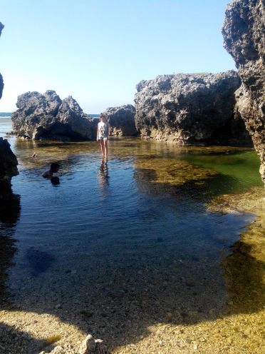
The coral rocks can rise as high as four meters above the water line.

Until now, it is only this particular area where fishermen can safely dock their fishing boats and rafts (with the exception, of course, of the more sandy shores of Victoria and Gaang that are already far away from the poblacion). The Spaniards erected the watchtowers precisely where the natural fortifications ceased.

Fortified Commercial Complex?

A good fortification utilizes elements in its surroundings to its advantage. The coral rocks and the watchtowers complemented each other in as far as guarding Currimao and its commercial activities were concerned. This outstanding system of natural barriers and man-made fortifications made the poblacion of Currimao a highly defensive coastal settlement by Philippine standards at that time. With the presence of the ruins of an almacen and an aduana, a functioning agua del pozo and pantalan, as well as two garitas, together with its imposing long coral rock formations, it is only fitting to reassess, rethink, and reintroduce the poblacion of Currimao – yes, the small, sleepy town – as an intact, fortified, Spanish-period commercial complex that might be hard to match elsewhere in the country.

IMG_20160803_024646_967

Legend: Blue – location of the almacen, aduana, pozo del agua, and pantalan; red – the two garitas declared as National Cultural Treasures; grey – the coastal areas with coral rocks.


___________________________

[1] Performed cultural mapping and documentation in town on March 14, 2016 for www.philippineheritagemap.org

[2] Presently housing the Ilocos Norte Museum

[3]“Pending cultural properties for consideration for declaration as Important Cultural Properties or National Cultural Treasures by the National Museum in 2016” http://www.ivanhenares.com/2015/12/national-cultural-treasure-2015.html

[4] http://philippineheritagemap.org/reports/14231c4b-5ae5-46ac-a911-77d384e4bf1f

[5] http://philippineheritagemap.org/reports/54b3d96f-5c09-4cc6-b4af-f5cf8aed0d78

[6] http://philippineheritagemap.org/reports/85df66cc-a2f5-4a5a-a704-506c873f4984

[7] Javellana, R (1997). Fortress of empire: Spanish colonial fortification of the Philippines, 1565 to 1898. Manila: Bookmark. Also look at http://simbahan.net/2009/08/27/fortress-of-empire-rene-javellana-sj/

[8] Fort San Andres was a component of the now widthrawn “Spanish Fortifications of the Philippines” nomination for UNESCO World Heritage Site listing. It is also a declared National Cultural Treasure. Its twin Fort Santiago is already in ruins. Also look at http://pamana.ph/fort-san-andres/

[9] http://philippineheritagemap.org/reports/ede424b7-984b-4e21-ac9e-e83c3d45241a

[10] http://philippineheritagemap.org/reports/df3a9836-4f09-441f-9745-a0fa6049ef42

[11] http://ncca.gov.ph/national-museum-bares-2015-list-of-cultural-treasures-properties/

Melaka and George Town: Trade Hegemons of Colonial-era Southeast Asia

Standard

Since there is not much noise being made about George Town while unanimous praises are given to Melaka (Malacca), I was surprised to find out that the former component-city would be the highlight of Malaysia’s first UNESCO cultural world heritage site that was inscribed in 2008. The character of George Town is definitely more presentable.


Melaka has a rich cultural and trading history, and the role it once played in regional commerce cannot be underestimated. Its current condition, however, does not live up to its glorious past anymore. Without knowing its history, the city simply looks like any other Chinese-Malay trading town.

The red Dutch Square, the most recognizable exponent of Melaka.

Its history dates back to the well-networked and influential Malaccan sultanate, and later gained greater worldwide interest when it was occupied by the Portuguese and the Dutch successively. Though Melaka was never made as a capital of the Dutch East Indies (VOC), it served as the most important Dutch-controlled port-town between India and Batavia (present day Jakarta), monopolizing the trade movements over the narrow Straits of Malacca. Melaka was such a strong city then that it even rivaled the might and wealth of Ayutthaya in Thailand, yet it fell with the rise of the British control over the peninsula.

Porta da Santiago, or A' Famosa, is the only remaining section of the old walls that once protected Melaka.

This ancient city’s important monuments  can be easily explored in a day, on foot. I started off in the residential/commercial district of the core zone, just across the bridge over the Melaka River. From how I recall, nothing really stood out in that area, and its main thoroughfare Jonker Street (popularly pronounced nowadays as /djongker/ despite its original Dutch pronunciation /Yongker/) was a bit sober and empty during my visit as it was post-election time; most shops were closed in protest against the recent results. The spirit of Jonker Street, nevertheless, went to life when I visited some of the shop houses, learning some few things from store-keepers about the items that they sell. Only then can one feel that he is truly in a multi-cultural trading town.

Shop houses along Jonker Street in Melaka

The Street of Harmony, situated parallel to Jonker Street,  is nice, but its religious monuments are not as spectacular compared to those of George Town. The urban planning concept of putting houses of worships along one lane is one of the unique features of the two historic cities.

The oldest Chinese temple in Malaysia, the Temple of the Goddess of Mercy (Cheng Hoon Teng Temple)

The Dutch Square, also called Red Square, is small but very recognizable. While it is indeed picturesque, there is not much that the plaza has to offer other than four monuments: the Dutch Stadthuys  and Christ Church, Tan Beng Swee Clock Tower, and the British Queen Victoria Fountain. The red color of the city is often seen as impressive, but I’m not quite sure if I share the same assessment. After all, the old historic Dutch buildings were originally painted white. 

The better exponent of Melaka where one can feel its colonial past more would be the A’ Famosa – St. Paul’s Hill area. Inside St. Paul’s ruins, there are numerous 16th to 17th century Dutch gravestones on display. This site was also the first resting place of the mortal remains of St. Francis Xavier before it was transferred to Goa in India. It is said that during the canonization of the saint, the Vatican asked for his right hand as a relic for its safekeeping. Interestingly, the statue of St. Francis Xavier in front of the ruins is missing its right hand! Apparently, a branch of the tree fell over and broke it.

Dutch gravestones inside the ruins of St. Paul church.

The St. Paul ruins also offers a commanding view of the city and the straits. Other interesting monuments in Melaka would be the watermill along the river, just beside the ruins of the old Portuguese and Dutch ramparts, and the small windmill near the Dutch Square.

The Malacca Sultan Watermill along the Melaka River.


George Town, on the other hand, was a real surprise. Historically, this British-era city rose to prominence with the decline and demise of Melaka. Without expecting much, I originally planned to stay there just for a night. But, seeing how lovely the place was, I ended up staying for three days. I enjoyed going around the city on a bike. Aside from surveying the main sites, there are other things to do here like checking out the street arts (which became a big craze after a Lithuanian artist did some wonderful works in the city), as well as treating oneself with the famous Penang dishes like Penang laksa and char kway cheow.

Georgian architecture-inspired George Town City Hall.

There are more monuments in George Town, and they are more grand, colorful, and definitely better maintained than those in Melaka. Key British legacies include the impressive Georgian-inspired City and Town Halls, the bit worn-out and empty Fort Cornwallis, the two mid-sized churches, and the colonial-era buildings along Lebuh Pantai, the old business lane of the city. By seeing some old photos of George Town, I was surprised to learn that there were more British colonial buildings that stood there before, creating a real “Little Europe” atmosphere during its heyday.

mix-architecture houses in George Town. Most are shop houses.

George Town was intended to be the successor to Melaka’s trade hegemony, as well as the crowning glory of the British empire’s might and supremacy in Southeast Asia. In comparison to Melaka, the historic centre of George Town is larger and that there are more shop houses around.

Fort Cornwallis, a brick fortification built upon the site where Sir Francis Light first landed in Penang.

Furthermore, I enjoyed the city a lot as local colours are much vibrant there. Its Little India, for example, is one of the better Indian quarters I’ve seen so far in the region; Muslim communities (Southern Indians and Malays alike) are largely concentrated around George Town’s three mosques; and the Chinese clan temples are richly decorated. In experiencing the straits Chinese-Malay culture, the Pinang Peranakan Mansion in George Town appears to be better than the Baba Nyonya Museum in Melaka. Also, George Town’s Teochew Temple and Cheong Fatt Tze Mansion have been conferred by UNESCO Asia-Pacific with the Best in Heritage Conservation Awards as well.

Masjid Kapitan Kelling along the Street of Harmony in George Town

Melaka is one reminder of Asia’s close contact with the Portuguese and the Dutch; George Town, with the British. Key to a better appreciation of these sites is to see each city holistically and to understand the diversity and cultural uniqueness that each has to offer.

DSC_0645

As with any South and Southeast Asian trading town such as Vigan, Hoi An, Macao and Galle, the biggest threats at present to the two cities are urban developmental pressures. Buffer zones are obviously weak in some areas. The waterfront face-lifting of the Melaka River and the intrusive development plan in the historic enclave of George Town have been frowned upon by the World Monuments Fund and other international organizations.

Street art in George Town - this is the biggest! Here's a photo of my newly found friends doing some rounds around the city at 2AM (after a night of booze!) :p


PS. Is it possible to have Singapore inscribed, too? Trade control in the Straits of Malacca started in Melaka, then transferred to George Town, and eventually ended in Singapore. It would be nice to see Singapore alongside the two inscribed sites in representing the complete trading history along the straits. The difficulty with Singapore, however, is that much of its old district landscape has already been altered, modernized and compromised.

** Visited George Town and Malacca in May 2013